Tropical Storm Isaias Near North Coast of The Dominican Republic, Hurricane Warnings Issued For The Northwestern Bahamas

WEST PALM BEACH, FL – According to the National Hurricane Center, the government of the Bahamas has issued a Hurricane Warning for the Northwestern Bahamas. So far a Hurricane Warning is in effect for Northwestern Bahamas including Andros Island, New Providence, Eleuthera, Abacos Islands, Berry Islands, Grand Bahamas Island, and Bimini.
A Tropical Storm Warning is in effect for the Dominican Republic’s entire southern and northern coastlines including North coast of Haiti from Le Mole St Nicholas eastward to the northern border with the Dominican Republic. Turks and Caicos Islands, Southeastern Bahamas including the Acklins, Crooked Island, Long Cay, the Inaguas, Mayaguana, and the Ragged Islands, Central Bahamas, including Cat Island, the Exumas, Long Island, Rum Cay, and San Salvador.
A Tropical Storm Watch is in effect for the East coast of Florida from Ocean Reef to Sebastian Inlet. According to the National Hurricane Center, interests elsewhere along the southeast coast of the United States should also monitor the progress of this system. Additional watches or warnings may be required for a portion of the Florida peninsula tonight or Friday.
A Hurricane Warning means that hurricane conditions are expected somewhere within the warning area. A warning is typically issued 36 hours before the anticipated first occurrence of tropical-storm-force winds, conditions that make outside preparations difficult or dangerous. Preparations to protect life and property should be rushed to completion.
A Tropical Storm Warning means that tropical storm conditions are expected somewhere within the warning area within 36 hours.
A Tropical Storm Watch means that tropical storm conditions are possible within the watch area, generally within 48 hours.
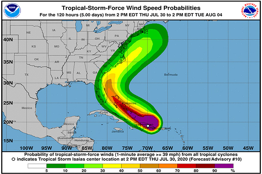
At 8:00 pm, the center of Tropical Storm Isaias was located near latitude 19.9 North, longitude 71.2 West. Isaias is moving toward the northwest near 20 mph, and a northwestward motion with some decrease in forward speed is expected over the next couple of days. On the forecast track, the center of Isaias will move near the Southeastern Bahamas by late tonight. Isaias is forecast to be near the Central Bahamas Friday night and move near or over the Northwestern Bahamas and near South Florida on Saturday.
Maximum sustained winds are near 60 mph with higher gusts. Strengthening is forecast during the next day or so, and Isaias is forecast to become a hurricane on Friday or Friday night. Tropical-storm-force winds can extend outward up to 240 miles from the center.
A dangerous storm surge will raise water levels by as much as 3 to 5 feet above normal tide levels in areas of onshore flow in the central and northwest Bahamas. Storm surge will raise water level by as much as 1 to 3 ft above normal tide levels in the southeastern Bahamas.
Tropical storm conditions will continue to spread across portions of the Dominican Republic, Haiti, the southeastern Bahamas and Turks and Caicos within the warning area tonight. Tropical storm conditions are expected to begin in the central Bahamas Friday morning and spread into the northwestern Bahamas beginning late Friday. (https://buckstovepoolandspa.com/) Hurricane conditions are expected within portions of the the northwestern Bahamas Friday night and Saturday. Tropical storm conditions are possible in the watch area in Florida beginning Saturday.
A Tropical Storm Isaias Forecast Discussion on the web at www.hurricanes.gov/text/MIATCDAT4.shtml.


Comments are closed.