Serene Skies and Perfect Weather: Pacific Northwest’s Tranquil Treat Until Thursday
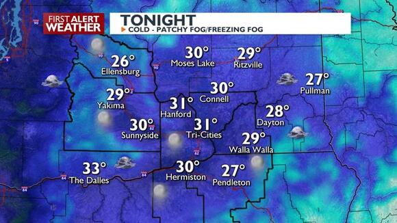
Tonight, temperatures will drop into the 20s and low 30s, which could cause any fog that forms to turn into patchy freezing fog, creating slippery spots on the roads by morning.
A calm stretch of weather is settling over the Pacific Northwest as high pressure builds steadily in the region. This high-pressure system will lead to mostly dry conditions, but it also increases the chances of fog or low cloud cover, especially in areas typically prone to fog, such as the Yakima and Kittitas Valleys, as well as the lower Columbia Basin.
Tonight, temperatures will drop into the 20s to low 30s, creating the potential for fog to form. In these colder temperatures, the fog may develop into patchy freezing fog, which could result in slippery road conditions in the morning. For Thursday, daytime highs are expected to be in the low to mid-40s for lower elevation areas, with seasonably cool temperatures throughout the day.

The weather will take a turn on Friday as a weak trough and a frontal system move through the region, bringing a change in conditions. This will result in rain and mountain snow, with the potential for some wet weather to spread across the area. Here’s what you can expect:
As Friday progresses, a weak trough and front will bring changes to the weather, resulting in rain and snow across the region. The precipitation will first appear along the Cascades in the morning, gradually moving eastward throughout the day. By late afternoon, most areas will experience some form of precipitation, though it will retreat to the mountains by Friday night.
The amount of precipitation will vary depending on location:
• Mountain Areas: Expect up to 0.50 inches of precipitation near the mountain crests.
• Foothills: Areas near the foothills may receive between 0.25 to 0.50 inches of rain or snow.
• Lower Elevations: For most lower elevation regions, only a few hundredths of an inch of precipitation is anticipated.
In terms of snow, snow levels will start out relatively high, with elevations around 4,000–5,000 feet in Washington’s Cascades, 7,000 feet in Oregon’s Cascades, and 2,500–3,500 feet in the Blue Mountains. By Saturday morning, snow levels will drop significantly to 2,000–2,500 feet, but the snow accumulation is expected to be light for most areas. However, higher snow amounts are likely at the mountain crests.
Winds will remain light during the day on Friday, but will intensify Friday night as the front moves in. Gusts of 30–40 mph are possible, particularly in the Columbia Basin, Simcoe Highlands, Kittitas Valley, and Blue Mountain foothills. Although the wind gusts are not expected to reach advisory levels, they may create challenges for high-profile vehicles on the road or cause loose items to blow around.
Saturday:
As the weather system from Friday moves out, the Pacific Northwest will see lingering light snow in the Cascades and eastern mountain areas. Snow levels will remain around 2,000 feet, though snowfall accumulations will be minimal—generally less than an inch in most places. The lower elevations, including the Columbia Basin, will stay dry throughout the day, but conditions will be breezy. Winds from the west to northwest will gust between 15 and 25 mph, particularly in the Columbia Basin and other wind-prone areas.
Sunday:
A weaker weather system will pass over the region on Sunday, bringing only a slight chance of snow to the mountain areas. Snow levels will hover between 1,500 and 2,500 feet, meaning snow will be limited to higher elevations. While the lower elevations will remain dry, the mountains may see light snow accumulation. The highest peaks will have a 20–40% chance of receiving up to an inch of snow, but overall snow accumulation will be minimal across the region.
Monday through Wednesday:
By Monday, high pressure will regain control over the region, bringing dry and stable weather conditions. Temperatures will cool slightly compared to the weekend, with daytime highs reaching the mid-30s to low 40s, while nighttime lows dip into the 20s. The clear, calm weather associated with high pressure will also bring the possibility of low stratus clouds or fog, particularly in the Columbia Basin, where fog is more common during stable weather patterns.
To summarise:
• Tonight through Thursday: Expect calm and dry conditions, though watch out for freezing fog in lower-lying areas.
• Friday: Rain and snow will arrive, with snow levels starting high but dropping by Saturday morning. Breezy conditions will develop later in the day.
• Weekend: Light snow will linger in the mountains, while the lower elevations stay dry and breezy.
• Next Week: Dry and quiet weather will return, bringing cooler temperatures and the possibility of fog in valley areas.
Stay warm, be cautious of foggy mornings, and enjoy the changing weather patterns!


Comments are closed, but trackbacks and pingbacks are open.