


Meteorologists are warning that the coldest Arctic air of the season is set to descend upon the United States, marking yet another punishing wave in an already relentless winter. This latest cold snap will serve as an icy exclamation point on what has been a season of repeated polar vortex disruptions, and it is expected to maintain its grip well into next week.
The driving forces behind this deep freeze originate in the Arctic, where multiple weather systems are interacting to push frigid air far beyond its usual domain near the North Pole. This time, the cold surge will not only impact the United States but also extend into parts of Europe, according to meteorologists who spoke with The Associated Press.
Judah Cohen, a seasonal forecast director at Atmospheric and Environmental Research, explains that this will be the 10th instance this winter where the polar vortex—a system of strong winds that normally confines the coldest Arctic air to the top of the world—has been stretched like a rubber band, allowing the bitter cold to spill southward. In a typical winter, such polar vortex disruptions occur only two or three times, making this season highly unusual.
An Unprecedented Winter of Extremes
This winter has already proven to be anything but normal. From record-breaking snowfall in New Orleans to severe drought and devastating wildfires in Southern California, the season has delivered a series of extreme weather events across the country.
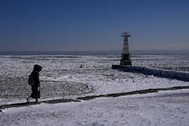
The latest cold outbreak is expected to first strike the northern Rockies and northern Plains on Saturday, before expanding and lingering throughout the following week. Meteorologists predict that the most intense cold will settle east of the Rocky Mountains, with only the far western U.S. and central and southern Florida escaping its grip.
Private meteorologist Ryan Maue, a former chief scientist at the National Oceanic and Atmospheric Administration (NOAA), has calculated that by Tuesday, the average low temperature across the Lower 48 states will be 16.6°F (-8.6°C), dropping further to 14°F (-10°C) on Wednesday. At the height of the cold snap, 89% of the contiguous United States will be below freezing, with 27% of the Lower 48 plunging below 0°F (-18°C), according to National Weather Service forecasts.
Adding to the misery, strong winds will exacerbate the brutal conditions, making temperatures feel even colder. According to the National Weather Service, every state except Hawaii, California, and Florida will experience wind chills as low as 20°F (-6.7°C) or lower at some point next week. The most extreme cold is expected to affect Kansas, Nebraska, Missouri, and Iowa, where temperatures could drop as much as 35°F (19°C) below average for this time of year, according to Zack Taylor, a meteorologist at NOAA’s Weather Prediction Center.
By Wednesday, the cold will be particularly intense across Oklahoma, Colorado, Nebraska, Missouri, Illinois, Iowa, Kansas, Wyoming, Montana, North Dakota, South Dakota, Minnesota, Wisconsin, and Michigan, where subzero temperatures are forecasted. While some areas may see additional winter storms—bringing threats of flooding, heavy snowfall, or even a nor’easter—the exact details remain uncertain, Taylor noted.
Why Is This Happening So Often?
Meteorologists are closely monitoring why the polar vortex has been stretching so frequently this winter. This particular type of disruption occurs when the vortex remains strong but bends and elongates, rather than weakening entirely and allowing cold air to escape en masse. Unlike a sudden stratospheric warming event—where a breakdown in the vortex causes a massive release of Arctic air—these stretching events tend to be slightly less extreme but still result in prolonged cold spells, primarily affecting the United States rather than Europe.
Experts are debating whether this winter’s persistent polar vortex stretching is a result of natural variability or a sign of broader climatic shifts. Laura Ciasto, a meteorologist at NOAA’s Climate Prediction Center, suggests that while the frequency of these events is unusual, it is not unprecedented. Meanwhile, Martin Stendel, a scientist at the National Center for Climate Research in Denmark, points out that other atmospheric factors are contributing to the vortex’s behavior this season.
One key influence is a high-pressure system over Greenland, which is currently shifting westward. This system is affecting the jet stream, the fast-moving air current that guides weather systems. As the jet stream bends into an amplified pattern, it is allowing Arctic air to plunge southward and remain trapped over the U.S. for an extended period, Cohen explains.
Some scientists believe human-caused climate change could be playing a role in making the jet stream more erratic, causing it to become wavier and more stagnant, which could be contributing to these repeated Arctic blasts.
A Cold Winter Amid a Warming Planet
Despite the brutal winter conditions in the U.S., the overall trend of global warming remains intact. January 2025 set yet another monthly global heat record, making it the 18th out of the last 19 months where Earth’s average temperature has exceeded or met the internationally recognized warming threshold of 1.5°C (2.7°F) above pre-industrial levels.
Maue emphasizes that there are few historical precedents for a winter like this, making it difficult for meteorologists to predict exactly when the extreme cold will finally retreat. For now, all indications point to another week of biting, relentless Arctic air, with the U.S. experiencing its most severe cold snap yet in an already punishing winter season.
Comments are closed, but trackbacks and pingbacks are open.