


This Valentine’s Day morning in North Texas brings a chilly start, with temperatures dipping into the 30s. The sky is partly cloudy, allowing for glimpses of sunshine between passing clouds. While there’s no heavy precipitation, the crisp air and cool conditions make for a brisk start to the day, setting the tone for a wintery holiday.
Compared to the same time yesterday, temperatures in North Texas have risen by about 15 degrees, signaling a shift toward a milder weather pattern. This increase is an early indication of a warmer airmass moving into the region, bringing more comfortable conditions as we head into the start of the weekend. Residents can expect a noticeable difference in the coming days as the chill gradually gives way to warmer temperatures.
Friday in North Texas is expected to remain cool, with a slight chance of rain throughout the day.
High temperatures will gradually climb into the upper 40s and low 50s, offering a modest but noticeable warmth. As surface winds shift to a more south-southeast direction, they will begin drawing in additional low-level moisture from the Gulf. This increase in moisture will help maintain persistent cloud cover, keeping the sky mostly overcast. Additionally, the rising humidity levels will introduce a small chance of scattered showers developing later in the afternoon and into the evening hours.
On Saturday, the chance for showers will persist through the morning and into the afternoon, particularly for areas east of the I-35 corridor. These rain chances come ahead of a strong cold front that is set to sweep through later in the day, bringing yet another surge of cold air by evening.
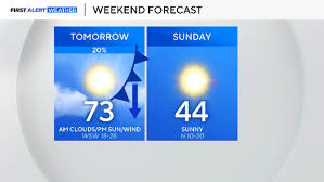
The temperature shift over the weekend will be dramatic, almost like experiencing two different seasons in just 24 hours. Saturday will feel spring-like, with highs reaching the low 70s, offering a brief taste of warmth. However, as the cold front moves in, temperatures will plummet overnight, making way for a much colder Sunday, when highs will struggle to rise beyond the mid-40s. This sharp drop will once again remind North Texans of winter’s lingering presence, making it a weekend of stark weather contrasts.
The First Alert Meteorology Team is closely monitoring an upcoming significant weather shift expected to impact North Texas early next week. A developing storm system is set to move into the region between Tuesday and Wednesday, bringing another round of dramatic temperature changes.
As the system approaches, conditions will remain relatively mild before a sharp drop in temperatures begins Tuesday afternoon. By Tuesday evening into Wednesday, the colder air mass will firmly take hold, causing temperatures to plummet. This shift could bring notable weather impacts, so residents should stay tuned for further updates as the system develops.
One of the biggest challenges in the upcoming forecast is predicting the precipitation chances. The latest run of long-range weather models suggests a decrease in the likelihood of rain, but the exact timing of the system remains uncertain.
At this point, there is a low-end chance that cold rain could develop late Tuesday into early Wednesday. As temperatures drop further, there is also a possibility that the rain could transition into a wintry mix or even light snow by Wednesday morning. However, confidence in this scenario remains low, and meteorologists are continuing to track the system closely.
Regardless of precipitation, the cold air behind the front will be significant. Morning temperatures are expected to plunge into the teens by Wednesday and Thursday, marking a bitterly cold stretch for North Texas. Residents should be prepared for freezing conditions and stay tuned for updates as the forecast evolves.
Comments are closed, but trackbacks and pingbacks are open.