


South Carolina is bracing for intense thunderstorms that will bring severe weather across the state, including heavy rain, flash flooding, high winds, and hail. The National Weather Service has issued Severe Thunderstorm Warnings for multiple counties, including Charleston, Greenville, and Columbia, as the storm system strengthens and moves eastward. With damaging winds, hail, and potential flooding, residents are urged to take immediate action to stay safe.
Severe Thunderstorms Expected Across South Carolina
The storm system will begin affecting central and eastern parts of South Carolina this afternoon, bringing heavy rain and frequent lightning. Charleston, Columbia, and Greenville can expect wind gusts up to 70 mph and hail up to 1 inch in diameter, which could cause significant damage to vehicles, roofs, and crops. These thunderstorms will intensify as they move east, with coastal areas like Myrtle Beach and Hilton Head seeing the worst of the weather by the evening. If you’re in the path of the storms, seek shelter immediately and avoid going outside unless necessary.
)
Flash Flooding a Major Threat
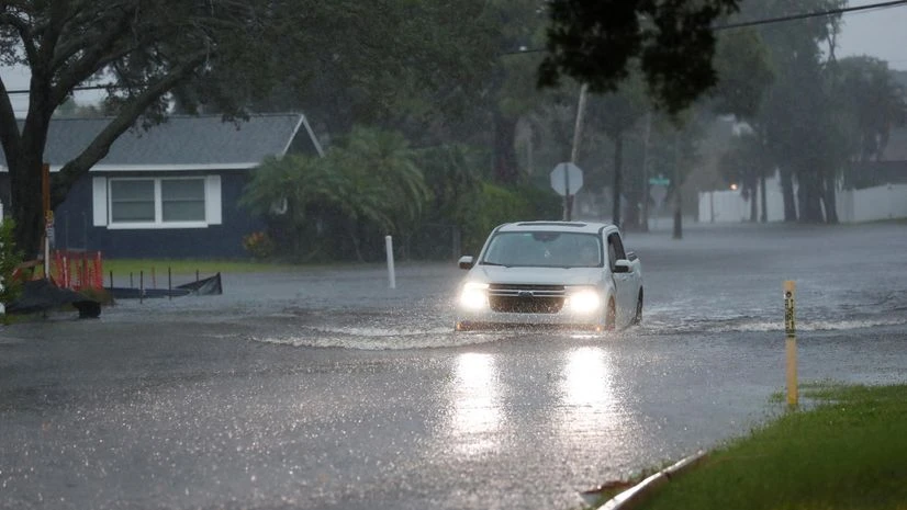
With the anticipated heavy rainfall and already saturated grounds from previous storms, the risk of flash flooding is high, especially in low-lying areas and near rivers. Interstate 26, Interstate 95, and other major highways in Charleston and Sumter counties could become inundated with floodwaters, making driving conditions dangerous. Charleston, Greenville, and Columbia are at heightened risk for flash flooding. Drivers should be cautious and avoid flooded roads at all costs, as even a few inches of water can sweep vehicles away.
Strong Winds and Hail Could Cause Significant Damage
In addition to heavy rain, the storms will bring strong winds and hail, with gusts reaching up to 70 mph in some areas. This could lead to downed trees and power lines, causing widespread power outages. Hailstones up to 1 inch in diameter are expected to damage roofs, vehicles, and crops. Local authorities are advising residents to secure outdoor objects like patio furniture and trash cans and to avoid standing near windows or trees during the storm.
Power Outages and Travel Disruptions Likely
Power outages are likely across South Carolina as high winds and flash flooding impact the state. Cities like Charleston, Columbia, and Greenville could experience power disruptions, and authorities are urging residents to prepare for outages by charging devices, gathering flashlights, and ensuring they have emergency supplies. Travel disruptions are also expected, with flooded roads and fallen trees potentially blocking major highways, including I-20, I-77, and I-95.
What You Can Do to Stay Safe
As the storm system approaches, it’s essential to follow these safety tips to protect yourself and your family:
-
Stay Indoors: Avoid going outside during the storm, especially when winds and hail are expected.
-
Monitor Weather Alerts: Keep an eye on weather updates from the National Weather Service, particularly if you’re in a Severe Thunderstorm Warning area.
-
Avoid Flooded Roads: Do not drive through flooded areas. If you come across flooded streets, turn around and find an alternate route.
-
Prepare for Power Outages: Charge your devices, stock up on non-perishable foods, and keep flashlights and batteries on hand in case of an extended power outage.
South Carolina is facing a dangerous weather event with severe thunderstorms, flash flooding, high winds, and hail expected to cause significant disruptions across the state. Power outages, property damage, and hazardous driving conditions are all likely, so residents should take immediate precautions to stay safe. By staying informed, securing outdoor items, and avoiding flooded roads, South Carolinians can minimize the risks posed by these powerful storms.
Comments are closed, but trackbacks and pingbacks are open.