

Warning: Severe Storms Targeting Lee County- Prepare for Power Outages and Dangerous Conditions!
 By Shiwangi Arya
Share with new partner:
By Shiwangi Arya
Share with new partner: A major storm system is set to bring dangerous weather conditions to Lee County over the next few days, with forecasters warning of severe thunderstorms, tornadoes, and flash flooding. While the week began with calm and sunny weather, conditions are expected to deteriorate rapidly as the weekend approaches.
Calm Before the Storm: Midweek Brings Pleasant Weather
Wednesday offers partly sunny skies and comfortable temperatures, with a high of 82°F (28°C). The morning may start with areas of fog, but the sunshine will break through by the afternoon. Nighttime temperatures will drop to 51°F (11°C), bringing crisp and cool air. Thursday will bring more sunshine, with a few high clouds rolling in later in the day. The high remains at 82°F (28°C), while the night will feel slightly warmer, settling at 54°F (12°C). By Friday, clouds begin to increase, signaling the start of changing weather patterns. Temperatures will reach 80°F (26°C) during the day, with warmer and more humid air settling in overnight, bringing lows of 62°F (16°C). The increase in humidity will help fuel the storm system expected over the weekend.
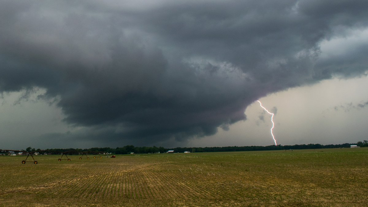
Weekend Brings Dangerous Storms and Tornado Threats
Saturday is when things take a serious turn for the worse. A powerful storm system will push through the area, bringing the threat of severe thunderstorms, damaging winds, and even tornadoes. Skies will remain cloudy and overcast, with showers and possible storms developing in the afternoon. The high will be 72°F (22°C), while the nighttime temperatures will stay warm at 64°F (18°C). Sunday looks even more threatening. Severe thunderstorms are likely, especially in the afternoon. Meteorologists warn that some storms could produce large hail, strong wind gusts, and isolated tornadoes. Flooding is also a major concern, as the ground will already be saturated from Saturday’s rain. The high will reach 80°F (26°C), with an uncomfortably warm and humid low of 69°F (20°C).
How to Stay Safe During the Severe Weather Threat
With the risk of tornadoes, heavy rain, and flooding, Lee County residents must take the necessary precautions before the storms arrive.
-
Stay Weather Aware – Keep an eye on weather alerts, and have a NOAA weather radio or a reliable weather app ready for instant updates.
-
Prepare for Power Outages – Charge your phones, stock up on batteries, and have flashlights and emergency supplies on hand.
-
Secure Outdoor Items – Strong winds can turn everyday objects into dangerous projectiles. Bring in lawn furniture and trash bins before the storms arrive.
-
Have an Emergency Plan – Identify a safe place in your home, such as a basement or an interior room away from windows, in case a tornado warning is issued.
-
Avoid Flooded Roads – Never attempt to drive through floodwaters. Just a few inches of moving water can sweep a vehicle away.
Relief Expected After the Storms
Monday will bring cooler and calmer conditions, but lingering showers and thunderstorms are still possible in the morning. The high will be around 79°F (26°C), with temperatures dropping to 58°F (14°C) at night. By Tuesday, sunshine finally returns, with pleasant conditions and a high of 66°F (19°C). The worst of the severe weather will have passed, but cleanup efforts may be necessary in some areas if storms cause damage. Lee County residents must take this severe weather threat seriously. Storms of this intensity can develop rapidly, leaving little time to react. Now is the time to prepare, stay informed, and ensure you and your loved ones remain safe throughout the weekend.
Comments are closed, but trackbacks and pingbacks are open.