


A dynamic storm system is heading into Montana this week, bringing scattered thunderstorms, large hail, and damaging winds. Forecasters say this pattern could trigger bouts of severe weather across much of the state.
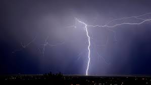
The National Weather Service has issued storm watches for parts of central and northern Montana, warning that atmospheric conditions—moisture-laden air clashing with unstable upper atmospheric flows—are creating a volatile setup. Isolated supercell development may produce hail up to tennis-ball size and wind gusts exceeding 60 mph, especially this afternoon and evening.
Montana’s tornado season officially began in April with a confirmed landspout tornado in the north-central region. While full-scale tornadoes remain less common, meteorologists note a low yet notable tornado risk this week—especially east of the Rockies where terrain-driven lift can fuel storm formation.
What You Need to Know
-
Storm timing & risk: Expect scattered storms mainly late afternoon through early evening. Some will likely reach severe thresholds.
-
Threats include: Large hail (up to 2″), wind gusts up to 60+ mph, heavy rainfall, and a slim chance of a weak tornado.
-
Where to monitor alerts: Keep an eye on storm watches posted for counties in central and north-central Montana.
Safety & Preparedness Tips
-
Stay alert with NOAA Weather Radio, mobile alerts, and local news updates.
-
Move indoors at the first sign of severe weather.
-
Keep a weather kit ready, with flashlight, batteries, and bottled water.
-
Tie down loose outdoor items to prevent wind damage.
-
Avoid sheltering under trees and stay clear of windows.
-
Drivers should slow down and avoid flooded roads or hail-ravaged routes.
Comments are closed, but trackbacks and pingbacks are open.