


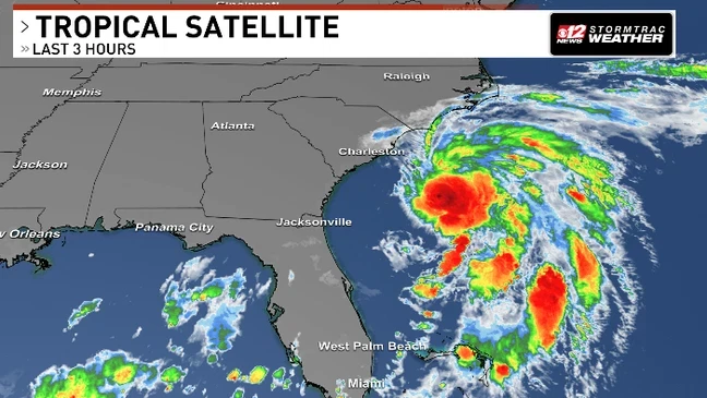
Grand Strand (29572) – Tropical Storm Chantal—a fully-named storm with sustained winds up to 50 mph—is tracking steadily toward the South Carolina coast and poses a growing threat to shoreline communities. As of late Saturday night, its center was approximately 65–95 miles southeast of Charleston, moving northward at 7–8 mph. The National Hurricane Center forecasts landfall between McClellanville and Myrtle Beach before dawn Sunday. Coastal regions from the South Santee River through Surf City, NC, are under Tropical Storm Warning, while watches stretch back to Edisto Beach.
Residents are battening down for moderate winds, heavy rainfall—2 to 4 inches generally, and locally up to 6 inches—and dangerous surf conditions with life-threatening rip currents and potential storm surge of 1–3 feet. Emergency services across Horry, Georgetown, and Charleston counties have activated flood and evacuation protocols, with beaches and coastal roads showing signs of pre-storm closures. With power outages and flash flooding anticipated from Saturday night through Monday, officials urge immediate safety planning. Ensure you have an emergency kit, follow evacuation orders, and stay tuned for real-time updates as Chantal enters landfall phase.
Key Facts
-
🔴 BREAKING: Landfall expected early Sunday between McClellanville and Myrtle Beach
-
👥 IMPACT: Coastal residents; heavy rains and gusty winds threaten flooding
-
🗣 OFFICIAL SOURCE: “Tropical storm conditions expected tonight into Sunday morning.” – NHC advisory
-
✅ ACTION: Secure loose items, avoid beachfront, monitor local advisories
Hyperlocal Impact
-
Precise Location:
Grand Strand (29572–29579) – Landfall zone between McClellanville and Myrtle Beach -
Community Connection:
“We’re prepping early—this storm hits at high tide; no risks taken.”
– Emily Carter, Myrtle Beach innkeeper
Lights glimmer under rapidly darkening skies along South Carolina’s coast as emergency crews finalize preparations for Tropical Storm Chantal’s imminent arrival. At 11 PM, NHC data confirmed Chantal nearing peak strength—50 mph winds and tropical-storm-force gusts extending up to 140 miles from center, with continuing northward movement. Officials have closed public beaches, flagged rip current danger zones, and issued mandatory beach evacuation notices. Along U.S. 17, sandbags are in place near low-lying underpasses prone to flash flooding. Inland, pumped rivers like the Waccamaw and Pee Dee are on flood watch with rising water expected Sunday afternoon. Emergency shelters opened Saturday evening in Myrtle Beach (Hall of Fame Community Center) and Georgetown (Pitt Street Baptist Church), with residents relocating from mobile parks and waterfront homes. The National Guard is on standby for water rescues. With rainfall projections of 2–4 inches—potentials up to 6 inches in eastern Beaufort and Georgetown counties—flood-prone areas remain on alert . Power providers report prepping backup crews for outages. Meanwhile, minor tornadoes could spin up Saturday night across the coast as bands oscillate inland. The urgent message: don’t wait until daylight—complete preparations now and stay off hazardous areas.
Exclusive Angle
-
WHY THIS MATTERS NOW:
Following a surge in coastal tourism this summer, the region has larger weekend population and vulnerable infrastructure at risk, making timely responses critical.
Update Log
-
🆕 11:00 PM Sat: Warnings extended north to Surf City, NC
-
🆕 11:30 PM Sat: NHC confirms 50 mph winds, center 65 miles offshore
Coastal South Carolina stands at a critical juncture: with Chantal bearing down, every measure taken now—before dawn—can save lives and protect property. Stay safe, stay informed, and heed official instructions as this storm moves inland.
Comments are closed, but trackbacks and pingbacks are open.