

Power Outages and Slick Roads Possible as Western Washington Braces for Lowland Snow

Western Washington is in for another dose of winter tonight, with lowland snow expected to blanket areas like Seattle, Tacoma, and Olympia. But it’s not just the snow that has officials worried—temperatures are expected to drop into the 20s, creating icy, dangerous road conditions for the Thursday morning commute. If you’ve got morning plans, you’ll want to prepare for delays or, better yet, stay home if possible.
How Much Snow Can You Expect?
It depends on where you live. Most areas will see anywhere from a dusting to about 3 inches, with higher amounts possible in neighborhoods at higher elevations or closer to the foothills. Snowfall will start after sunset and continue into the early hours of Thursday morning.
This won’t be a storm where everyone sees the same results. One area could get a quick burst of snow, while a neighborhood just a few miles away barely sees any. “It’s going to be spotty,” said a local meteorologist. “Some places might wake up with a winter wonderland, and others might just have a light coating.”
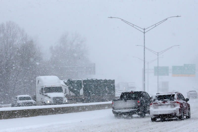
It’s the Ice That Could Be a Real Problem
While snow is a nuisance, the bigger issue is the ice. With temperatures dropping into the 20s overnight, any moisture on the roads will freeze quickly. Black ice—that sneaky, nearly invisible layer of ice—will be a major concern, especially on bridges, overpasses, and side streets.
WSDOT crews have been out pre-treating main roads, but black ice is tricky. Even treated roads can get slippery if the temperature drops fast enough. “Don’t let the roads fool you,” warned a transportation official. “Just because you can’t see the ice doesn’t mean it’s not there.”
If you’re driving tomorrow morning, slow down, leave plenty of space between you and the car ahead, and give yourself extra time to get where you’re going. Side streets and untreated areas could be especially dangerous, so take it easy.
Could the Snow Knock Out Power?
It’s possible. Although this isn’t expected to be a major ice storm, wet snow and freezing conditions could weigh down tree branches and power lines, causing isolated outages. Rural areas and neighborhoods with a lot of trees are at the greatest risk.
Power companies are on standby and ready to respond, but residents should take precautions. Make sure your phone and backup chargers are fully charged, and keep flashlights, blankets, and non-perishable food handy. “If your power goes out, you don’t want to be scrambling in the dark,” said a local utility spokesperson.
How to Stay Safe Tonight and Tomorrow
- Avoid Driving if Possible: If you don’t have to be on the road tomorrow morning, delay your travel until later in the day when conditions improve.
- Drive Slowly and Watch for Black Ice: If you must drive, reduce your speed, brake gently, and be extra cautious on bridges and overpasses.
- Charge Your Devices: Power outages can happen without warning, so charge your phones, laptops, and portable chargers now.
- Have Emergency Supplies Ready: Keep flashlights, batteries, extra blankets, and snacks nearby just in case.
- Stay Updated: Check local weather reports frequently for the latest updates.
When Will Things Get Better?
The snow should stop by late Thursday morning, and temperatures will rise into the mid-30s, helping melt some of the snow and ice. But don’t let your guard down—temperatures will drop again Thursday night, leading to refreezing. Any leftover moisture on the roads could turn into black ice again, making Friday morning another tricky commute.
“We’re not out of the woods after one day,” warned a local forecaster. “Even if the roads look clear, icy patches could stick around in shaded areas or places that don’t get much sun.”
What’s Next?
Once this storm moves out, forecasters are keeping an eye on the weekend, when another possible weather system could bring more rain or snow to the region. For now, the focus is on getting through tonight and tomorrow safely.
Comments are closed, but trackbacks and pingbacks are open.