

Storm Surge: Twin Atmospheric Rivers Threaten Bay Area with Severe Weather!

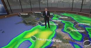
The Bay Area is in for a wet and wild week as not one but two atmospheric river systems roll in, bringing heavy rain, possible hail, and even some snow at higher elevations. The first storm is set to arrive late Tuesday night, soaking the region through Wednesday, and just as things start to dry out, another round of wet weather will move in by Friday.
If you have outdoor plans this week, you might want to rethink them—or at least have a good umbrella handy.
First Storm Arrives Tuesday Night
The first of the two storm systems is expected to hit the North Bay late Tuesday before making its way south across the region. This one will pack a punch, with steady rainfall expected through Wednesday, making for a messy morning commute.
- North Bay & Coastal Mountains: Expect 2 to 3 inches of rain.
- Other parts of the Bay Area: Likely to see 1 to 1.5 inches of rain.
The biggest concern? Flooding and hazardous road conditions, especially during peak travel hours. If you’re hitting the road Wednesday morning, be prepared for slow-moving traffic and possible standing water on freeways.
Thunderstorms & Hail in the Mix
This isn’t just your typical rainy day. The storm system is also bringing a 15-20% chance of thunderstorms, which means pea-sized hail, lightning, and gusty winds could make an appearance.
Winds could reach 30-40 mph, which may cause downed tree branches and power outages in some areas. So if you hear a rumble of thunder, don’t be surprised—it’s all part of this storm’s chaotic energy.
Watch Out for Big Waves
Coastal areas are also expected to feel the impact, with swells building up to 20 feet by midweek. The National Weather Service is warning against standing on rocks, jetties, or venturing too close to the shoreline, as the high surf could be dangerous.
A Brief Break on Thursday
After the first storm moves out, we’ll get a bit of a breather on Thursday. However, the cooler air behind the storm could drop snow levels to as low as 2,500 to 3,000 feet. While it won’t be a full-on winter wonderland, folks in the North Bay mountains and East Bay hills might see a dusting of snowflakes.
Round Two: A Second Storm Hits Friday
Just as the Bay Area starts to dry out, another atmospheric river will roll in on Friday, bringing another wave of heavy rain that could last into the weekend.
- Rainfall amounts will be similar to the first storm, with the heaviest precipitation expected in the mountains and coastal regions.
- Wind gusts and possible thunderstorms could return, making for another rough commute on Friday and into Saturday.
The back-to-back nature of these storms could increase the risk of flooding, especially in low-lying areas, so keep an eye on local weather alerts.
How to Prepare for the Storms
With two strong systems on the way, a little preparation goes a long way. Here’s what you can do:
- Check the forecast regularly for updates from the National Weather Service.
- Drive safely and allow extra time for commutes—roads will be slick, and visibility may be low.
- Avoid flooded areas—if you see standing water, turn around instead of trying to drive through.
- Secure outdoor furniture and decorations—strong winds could send lightweight objects flying.
- Charge your devices in case of power outages, and keep flashlights and candles handy.
Final Thoughts
The Bay Area is no stranger to winter storms, but two atmospheric rivers in one week is something to take seriously. With heavy rain, gusty winds, possible thunderstorms, and even snow in the mix, expect a dynamic weather pattern from Tuesday through the weekend.
If you have plans that require outdoor travel, stay flexible—this week is going to be a wet and unpredictable ride.
Stay safe, stay dry, and stay tuned for updates as these storms unfold!
Comments are closed, but trackbacks and pingbacks are open.