


Hurricane Milton intensified into a Category 4 storm on Monday, posing a severe threat to Florida’s Gulf Coast, particularly the Tampa Bay region.
Milton Expected to Hit Florida’s Gulf Coast
The storm, with 150-mph winds, is expected to make landfall late Wednesday, potentially becoming one of the most catastrophic storms the area has experienced in decades.
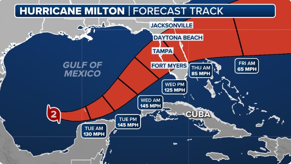
As of 9 a.m. Monday, the storm was approximately 735 miles west-southwest of Tampa, moving east-southeast at 8 mph. Hurricane-force winds extended 35 miles from its center, while tropical-storm-force winds reached up to 80 miles. With its current trajectory, Milton could strengthen to a Category 5 hurricane before hitting the coast, although forecasters are uncertain about the exact landfall location, citing a 100-mile margin of error.
Potential Impacts of Milton
Meteorologists have warned that Hurricane Milton could bring life-threatening conditions, including storm surge, heavy rainfall, and strong winds. The National Hurricane Center (NHC) predicted storm surges of up to 12 feet in parts of Tampa Bay, which is double the levels seen during Hurricane Helene. Areas from Pasco County to Yankeetown, as well as parts of southwest Florida, could experience surges up to 10 feet.
Rick Davis, a meteorologist from the National Weather Service in Tampa Bay, stressed the dangers of flooding and storm surge, highlighting that stormwater could inundate homes, particularly in low-lying areas. Additionally, up to 15 inches of rain are expected in some parts of the region, increasing the risk of flash flooding as Milton approaches.
Wind damage is also a significant concern. Milton is expected to bring “a tremendous amount of wind damage” as it nears landfall. Debris from previous storms, like Hurricane Helene, could become projectiles, causing further destruction and putting lives at risk. Davis warned that power outages are likely in the hardest-hit areas, potentially lasting for extended periods.
Urgent Preparations and Evacuations
As Milton’s arrival looms, meteorologists are urging residents to finalize their hurricane plans immediately. With conditions expected to deteriorate by Wednesday, it is time for Floridians in the storm’s path to either evacuate or secure their homes. Davis emphasized the urgency, advising people not to delay. “They need to put those plans in place now if they’re going to evacuate,” he said. “All plans need to be completed today and tomorrow because on Wednesday we’re going to start seeing some pretty bad conditions.” Though Milton could weaken slightly before landfall, experts caution that the storm’s impact will be severe regardless of its final category. “We don’t want people to be too concerned whether it’s a category 4 or category 3, the impacts locally are going to be tremendous,” Davis added.
Hurricane and Storm Surge Alerts Issued
Several watches and warnings were issued before Milton’s arrival. From Flamingo to the Suwannee River, the Gulf Coast of Florida is under a storm surge watch, indicating the potential for life-threatening flooding within the next 48 hours. A hurricane warning is in effect for parts of the Yucatan Peninsula, and a hurricane watch is active for Florida’s Gulf Coast, including the Tampa Bay area.

With Milton approaching, authorities continue to monitor the storm’s track and encourage residents to stay informed, follow evacuation orders, and take precautions as the dangerous hurricane advances toward Florida.
Comments are closed, but trackbacks and pingbacks are open.